Use APKPure App
Get trekking biking hiking old version APK for Android
Mappa offline, mappa Off-line, off line la mappa, GPS, trekking, trekking, escursioni a piedi, escursioni a piedi, in bicicletta, mountain bike
Ideal use for trek, trekking, hike, hiking, bike, biking and cycling with offline map.
Using GPS, it can show current speed and distance traveled. Overlaying current positions and target tracks in the map.
GPX exporting for drawing your path in the Google earth or built in map. http://utrack.crempa.net/ is a good program for analyze your tracks with altitude and speed. For this, you need to make sure to export tracks recorded as "Track" button when you exporting GPX since the website doesn't accept waypoint-based GPX file. http://www.routeconverter.de/home/en is also a quite good program too for having comprehensive capability of dealing with every GPX files.
In navigation pane, you can see current positions and distance traveled. You can change Font size dynamically fiting for the best view in your target device. Background/fore ground color can be changed in automatically adjusted with light sensor. Or you can fix it.
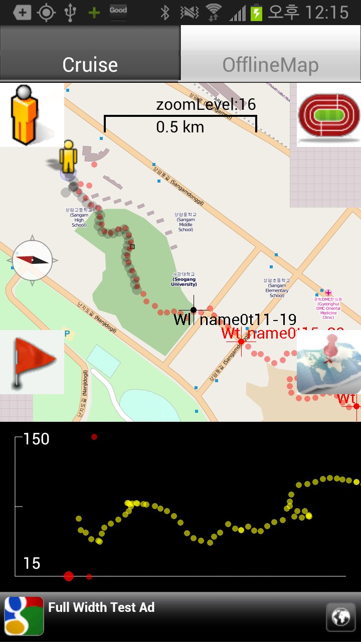
Off-line map pane without requiring Internet connection.
In off line map pane, you can overlay GPX track for you to have idea if you are tracking the target path closely and how far from the target path. Supporting Mapnik/Mapquest maps through Mobile Atlas Creator(which is available in the host PC). Marked POIs in the navigation pane are being drawn as logging POIs. Can navigate quickly to track, where am I, and POIs with buttons in the screens. Target track/POIs are being shown in red color and logging tracks (my position trails)/POIs are shown in black color. Split screen shows altitude target (yellow) , and current altitude(white), which can be dynamically enabled/disabled with screen button(mountain figure).
Temp/baro/humidity sensors reading and trends(in case that your device has these sensors).
Freely navigating between navigation and offline map panes.
Catch me/follow up function:If the app receives SMS message with valid latitude and longitude with, then the app parse the SMS message and file it as logging point.
Suppose that two groups are in trekking, then the first group might want to inform the location periodically to the latter group. Then the first group send a SMS to the latter group for them to chase with time stamp and short message.
Valid message examples and rule:
lat37.5793889 long126.884542 (there should be space between lat and long and no space between lat/long and corresponding numbers)
atitude37.5793889 longitude126.884542 (full name of latitude and longitude are being recognized)
provider:gps latitude37.5793889 longitude126.8845 (the logging POI shown with "G". if you don't specify provider, it shown with "U")
provider:network latitude37.5793889 longitude126.8845 (the logging POI shown with "N".)
we will wait here provider:gps latitude37.5793889 longitude126.8845 (message to be shown in the map)
catch me latitude37.5793889 longitude126.884542 (message should come earlier than "provider" or "lat/long")
There is an android app("One shot sms") which can automatically encapsulate the location info with message body as a reference. You just put message body and
send it with wLocation, then the message is automatically encapsulated with provider/and lat/long/accuracy of the position.
No Ads version is also available.
Last updated on Sep 14, 2015
1. Simplified track import; You can directly use a button in the track import screen instead of using option key.
2. More information with tracklist. Total distance, duration and number of points are to be provided with a track.
3. Rendering optimization with larger data(let say more than 4000 points)
+HotFix for preventing DB upgrade failures
Ultima versione
![]() 4.27
4.27
Caricata da
Kittisopon Boonsir
È necessario Android
Android 1.6+
Categoria
Segnala


Discover what you want easier, faster and safer.

trekking biking hiking
4.27 by JChoiDr
Sep 14, 2015